Sun paths behind the terrain
The grey silhouette is the terrain as it appears against the sky from the calculation point. Where the sun path disappears behind the silhouette, the point is in shadow.
Where exactly it was calculated: the measuring point
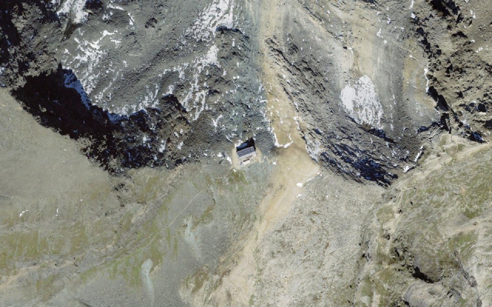
Aerial photo SWISSIMAGE © swisstopo, marker = measuring point
All times on this page apply to exactly one point: at the hut, 3,030 m above sea level (LV95 coordinates 2638416 / 1101071). The calculation starts from the highest terrain point within 20 m, 2 m above ground. The point matters: just 50 m further on, for example on the opposite shore or behind a terrain edge, the sun can disappear earlier or arrive later. If you want to check a specific spot, choose it yourself in the app. View the measuring point on map.geo.admin.ch
Sun path in 3D: Britannia Hut SAC over the course of the day
View from the point towards the sun, calculated with the real terrain, buildings and trees from the official 3D data. Choose a date, then move through the day with the slider.
Sun path from the SunPlot app: terrain swissALTI3D, buildings swissBUILDINGS3D, trees swissSURFACE3D, aerial photo SWISSIMAGE – all © swisstopo. Without clouds or weather.
Winter and summer compared
On the evening of 21 December, the sun disappears behind Rimpfischhorn to the south-west (9° above the horizon, 6 km away). On the morning of 21 December, the horizon to the south-east is practically clear. On the evening of 21 June, the sun disappears behind Klein Allalin to the west (30° above the horizon). On the morning of 21 June, the sun only appears from behind Pizzo d'Andolla to the north-east (4° above the horizon, 9 km away).
Over the year that makes 3,465 hours of sunshine; without the terrain it would be 4,401: the terrain takes 936 hours, or 21%.
Sun month by month (on the 15th of each month)
| Month | Sun windows | Hours | Possible |
|---|---|---|---|
| January | 8:24–15:44 | 7.3 h | 8.8 h |
| February | 8:16–16:24 | 8.1 h | 10.2 h |
| March | 7:56–16:28 | 8.5 h | 11.7 h |
| April | 7:04–17:24 | 10.3 h | 13.4 h |
| May | 6:12–17:52 | 11.7 h | 14.8 h |
| June | 6:08–18:08 | 12.0 h | 15.5 h |
| July | 6:20–18:12 | 11.9 h | 15.2 h |
| August | 6:48–17:36 | 10.8 h | 14.0 h |
| September | 7:28–17:12 | 9.7 h | 12.4 h |
| October | 8:48–17:08 | 8.3 h | 10.8 h |
| November | 7:56–15:48 | 7.9 h | 9.3 h |
| December | 8:12–15:28 | 7.3 h | 8.5 h |
Times CET/CEST, calculated without clouds; “possible” = sun above the mathematical horizon.
How this is calculated
- Terrain: swissALTIRegio (10 m) around the point, up to 25 km away, horizon in 1° steps from a distance of 30 m. Standpoint: highest terrain point within 20 m, eye level 2 m. Required source attribution (editions from 2025): Bundesamt für Landestopografie swisstopo; Tarquini S., I. Isola, M. Favalli, A. Battistini, G. Dotta (2023). TINITALY, a digital elevation model of Italy with a 10 meters cell size (Version 1.1). Istituto Nazionale di Geofisica e Vulcanologia (INGV). https://doi.org/10.13127/tinitaly/1.1; DGM Österreich, geoland.at; DGM1, Bayerische Vermessungsverwaltung – www.geodaten.bayern.de; DGM 1 Baden-Württemberg: LGL, www.lgl-bw.de, dl-de/by-2-0”; RGEAlti, Institut National de l’information géographique et forestière, données originales tétéchargées sur https://geoservices.ign.fr/rgealti#telechargement5m, mise à jour du juillet 2023
- Only the terrain casts shadows; buildings, trees and clouds are not taken into account.
- Astronomical sun position (NOAA approximation), year 2026, times CET/CEST. As of 2026-09-22.
- Sources: terrain and names © swisstopo. Not a weather forecast; no guarantee for individual cases.
Short answers
When does Britannia Hut SAC get sun in winter?
On 21 December from 8:16 to 15:32, that is 7.3 of 8.4 possible hours. In January and February it gets longer every day; the monthly table above shows the times for the 15th of each month.
Where does the shadow come from?
On the evening of 21 December the sun disappears behind Rimpfischhorn to the south-west.
How accurate is this?
The times come from the official terrain model and the astronomical position of the sun at the stated point. A few metres further on, or a tree in front, can make a difference of a few minutes. Weather is not included.